Gaat sleutelpublicatie in wetenschappelijke literatuur zeespiegelstijging voorbij aan basale natuurkunde?
In een belangrijk artikel in Nature werd gedemonstreerd hoe een theoretisch model voor de zeespiegelstijging, de budgetmethode, aansloot op satellietmetingen. (Bijna) iedereen was blij met dit resultaat dat terug te voeren was op het promotiewerk van Frederikse aan de TU-Delft in 2018. Maar GRK-auteur Evert Jesse deed wat de promotoren en peer reviewers nalieten en ontdekte een fundamentele fout in de aannames, die bijna te simpel is om te geloven (iets met de wet van communicerende vaten). Hij bewandelde de koninklijke weg en benaderde de auteurs en betrokkenen voor commentaar maar dat spoor liep dood. Nu is de kritiek aangeboden aan het blad Nature.
De Groene Rekenkamer plaatst de kritiek van Jesse in originele tekst en geeft de Nederlandse vertaling erbij. Het zou flink wat opschudding moeten veroorzaken. Want als de kritiek stand houdt, is terugtrekking van de Nature publicatie de enige logische weg. Oordeelt u zelf.
A critique of Nature Article
The causes of sea-level rise since 1900
Frederikse et.al.
Nature no. 584, pages 393-397, published August 2020
1. Summary
Satellite altimetry finds significant regional variations in the rate of sea level rise, which are in contradiction to many long term tide station records.
Nature Article “The causes of sea level rise since 1900”, further on referred to as F2020 and the subject of this critique, aims to settle this dispute by assuming that regionally varying rates of sea level rise are caused by differences in volumetric feed-in effect across the oceanic regions: thermal expansion, ice-mass loss, changes in Ocean floor elevation (GIA) and changes in terrestial water storage.
Its “Budget model” calculates these volumetric changes bottom-up and from this derives a rate of sea level rise for different ocean basins. The results are consistent with satellite records, both on a global and a basin scale, and based on this F2020 concludes that their assumption is correct, “…No other processes are required to explain the observations”.
This conclusion seems fundamentally wrong. The satellite measurements infer that over the past 30 years the ocean surface has gradually been deviating -and is still deviating- from the geopotential plane. This, if true, cannot be caused by the volumetric effects incorporated in the Budget model, as these do not provide the forces to counter the resulting hydrostatic pressure gradients. “Other processes”, such as changing external forces (atmospheric or currents) are indeed necessary, and would then fully explain regional variations in the rate of sea levl rise.
Analysing the Budget model shows that it violates basic hydrostatic laws, and the correlation found with satellite observations is therefore meaningless. This makes the conclusions drawn by F2020, also concerning earlier time periods, seem invalid. The difference between satellite measurements and tide gauges remains unresolved.
This conclusion seems fundamentally wrong. The satellite measurements infer that over the past 30 years the ocean surface has gradually been deviating -and is still deviating- from the geopotential plane. This, if true, cannot be caused by the volumetric effects incorporated in the Budget model, as these do not provide the forces to counter the resulting hydrostatic pressure gradients. “Other processes”, such as changing external forces (atmospheric or currents) are indeed necessary, and would then fully explain regional variations in the rate of sea level rise.
Analysing the Budget model shows that it violates basic hydrostatic laws, and the correlation found with satellite observations is therefore meaningless. This makes the conclusions drawn by F2020, also concerning earlier time periods, seem invalid. The difference between satellite measurements and tide gauges remains unresolved.
2. Discussion
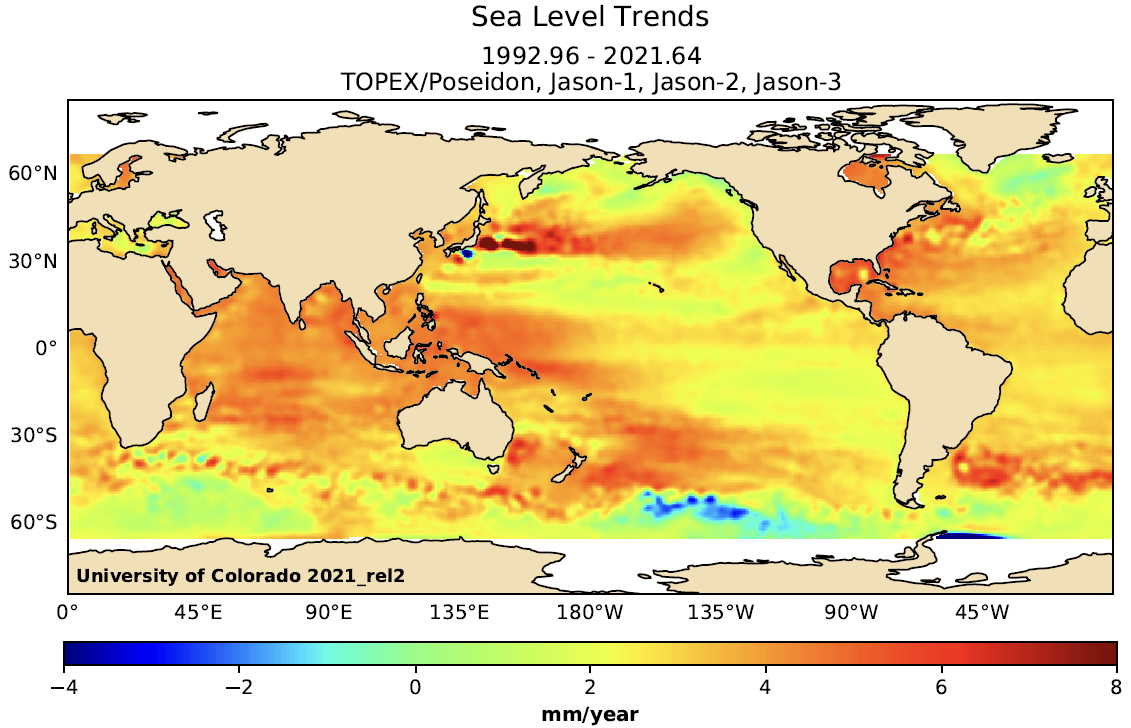
The satellite altimetry system finds significant regional variations in the historic rate of sea level rise, as shown in Fig.1:

Fig.1 sea level rise according to satellite altimetry (University of Colorado, Boulder)
The data in fig.1 represent the averages over a period of almost 30 years, implying that significant absolute differences in sea surface elevation must have been detected by the satellite system. As the sea surface generally follows the local gravity field this is a remarkable result, requiring an explanation before it can be accepted as fact.
Such an explanation might be found in changes in the geopotential plane relative to the orbital plane of the observing satellite, or by changing external forces on the ocean surface: atmospheric pressure changes, wind patterns or ocean currents.
F2020 however claims that these variations are only caused by differences in volumetric feed-in effects across the oceanic regions: thermal expansion, melting land ice, changes in ocean floor elevation (GIA) and changes in terrestial water storage. It does not offer a physical explanation for this, only a correlation:
“…The sum of the contributions to sea-level change from thermal
expansion of the ocean, ice-mass loss and changes in terrestrial water storage is
consistent with the trends and multidecadal variability in observed sea level on both
global and basin scales…”
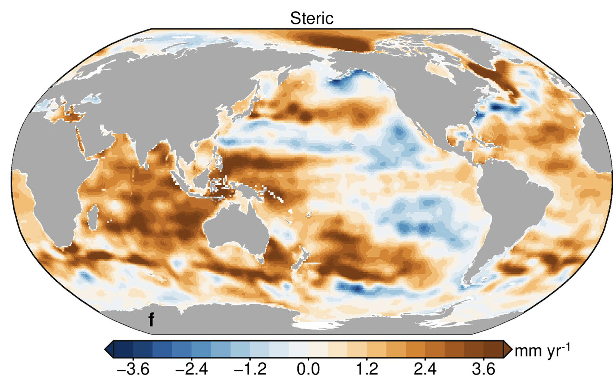
The problem here lies with the “multidecadal variability on basin scales”. This will be illustrated by analysing the results of the Budget model for the largest contributor, steric effects, which consists mostly of thermal expansion of the oceans. Fig 2 shows the results over the period of satellite records:

Fig.2 Calculated rate of sea level rise due to steric effects over the period 1993 to 2018
Note that the results largely correlate, in location as well as magnitude, with the variations in the rates of sea level rise in Fig.1.
Thermal expansion as a process is relatively uncomplicated. The mass of the water does not change and there is no influence on the shape of the Earth gravitational field. In a 1-dimensional analysis the rate of sea level rise at any place is only a function of the rate of warming and the length of the water column affected. This is the result shown in Fig.2 above.
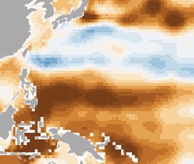
However, sustained regional differences in the rate of sea level rise inevitably lead to differences in actual sea surface elevation, thereby tilting the ocean surface relative to the local gravity vector. See for instance the Philippine Sea, which shows a significant gradient in the rate of sea level rise according to the Budget model:

Fig. 3 Detail of Fig.2 (Philippine Sea)
According to the Budget model the sea level has risen by 100 mm in the the south of the area shown over the 25 year period considered, and fallen by 50 mm north of this area. In the model the sea surface has therefore tilted (and is still tilting) relative to the geopotential plane.
This is an impossible result, as thermal expansion does not provide the forces to maintain the resulting hydrostatic imbalances. In the absence of other forces differential thermal expansion can only lead to a uniform rate of sea level rise relative to the local geopotential plane.
It proves that the budget model does not recognise this basic constraint. This is a fundamental flaw which makes its output meaningless to explain regional differences in the rate of sea level rise.
3. Conclusion
F2020 claims to have fully explained the regional variations in the rate of sea level rise as detected by satellite altimetry, and from that result concludes that the satellite altimetry data is correct.
However, their explanation is based on a bottom-up calculation model which allows the sea surface to deviate from the geopotential plane, without acknowledging that such a deviation requires external forces.
Such forces, if present, would then provide sufficient explanation for the detected differences in the rate of sea level rise. This makes the volumetric inflow effects identified by F2020 irrelevant.
The conclusions drawn by F2020, also concerning earlier time periods, are invalid.
Ir. E.Jesse
Hoofddorp, the Netherlands
November 10, 2023
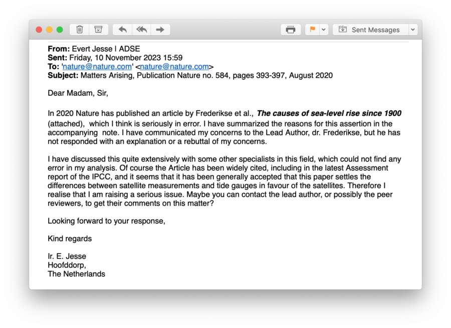
Op 10 november 2023 schreef Evert Jesse de redactie van Nature aan met de volgende brief (vetgedrukte nadruk in Nederlandse vertaling door redactie aangebracht):

In 2020 heeft Nature een artikel gepubliceerd van Frederikse en anderen, De oorzaken van zeespiegelstijging sinds 1900, waarvan ik denk dat deze ernstig foutief is. Ik heb een samenvatting van de redenen voor deze bewering in bijgevoegde notitie gegeven. Mijn bedenkingen heb ik gecommuniceerd met de hoofdauteur, dr. Frederikse, maar hij heeft niet geantwoord met een uitleg of een weerlegging van mijn bedenkingen.
I heb dit uitvoerig besproken met enkele andere specialisten op dit gebied, die geen fout konden vinden in mijn analyse. Natuurlijk is het artikel alom geciteerd, waaronder in het laatste IPCC rapport, en het lijkt erop dat het alom verondersteld wordt dat dit artikel de kwestie beslecht van de verschillen tussen satellietmetingen en peilschalen, ten faveure van de satellieten. Ik besef daarom dat ik een gewichtige zaak aanroer. Wellicht kunt u de hoofdauteur benaderen, of mogelijk ook de peer-reviewers, om hun commentaren te verkrijgen.
Ik zie uit naar uw antwoord,
Met vriendelijke groet,
Ir. E. Jesse
Hoofddorp

Euronen verlammen Neuronen denk ik. Dit zie je ook in de medische wereld.